


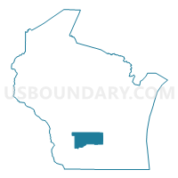
Sauk & Columbia Counties PUMA, Wisconsin
About
Outline

Summary
| Unique Area Identifier | 194403 |
| Name | Sauk & Columbia Counties PUMA |
| State | Wisconsin |
| Area (square miles) | 1,644.59 |
| Land Area (square miles) | 1,596.43 |
| Water Area (square miles) | 48.16 |
| % of Land Area | 97.07 |
| % of Water Area | 2.93 |
| Latitude of the Internal Point | 43.44695260 |
| Longtitude of the Internal Point | -89.66263190 |
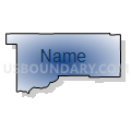
Maps

Graphs
Select a template below for downloading or customizing gragh for Sauk & Columbia Counties PUMA, Wisconsin


Neighbors
Neighoring Public Use Microdata Area (by Name) Neighboring Public Use Microdata Area on the Map
- Central Sands--Wood, Portage, Juneau & Adams Counties PUMA, WI
- Dane County (East) PUMA, WI
- Dane County (West) PUMA, WI
- Dodge & Jefferson Counties PUMA, WI
- East Central Wisconsin PUMA, WI
- Grant, Green, Iowa, Richland & Lafayette Counties PUMA, WI
- West Central Wisconsin--Northern Mississippi Region PUMA, WI
Top 10 Neighboring County (by Population) Neighboring County on the Map
- Dane County, WI (488,073)
- Dodge County, WI (88,759)
- Sauk County, WI (61,976)
- Columbia County, WI (56,833)
- Vernon County, WI (29,773)
- Juneau County, WI (26,664)
- Iowa County, WI (23,687)
- Adams County, WI (20,875)
- Green Lake County, WI (19,051)
- Richland County, WI (18,021)
Top 10 Neighboring County Subdivision (by Population) Neighboring County Subdivision on the Map
- Baraboo city, Sauk County, WI (12,048)
- Portage city, Columbia County, WI (10,324)
- Reedsburg city, Sauk County, WI (9,200)
- Windsor town, Dane County, WI (6,345)
- Columbus city, Columbia County, WI (4,991)
- Prairie du Sac village, Sauk County, WI (3,972)
- Bristol town, Dane County, WI (3,765)
- Sauk City village, Sauk County, WI (3,410)
- Lodi town, Columbia County, WI (3,273)
- Lodi city, Columbia County, WI (3,050)
Top 10 Neighboring Place (by Population) Neighboring Place on the Map
- Baraboo city, WI (12,048)
- Portage city, WI (10,324)
- Reedsburg city, WI (9,200)
- Columbus city, WI (4,991)
- Lake Wisconsin CDP, WI (4,189)
- Prairie du Sac village, WI (3,972)
- Sauk City village, WI (3,410)
- Lodi city, WI (3,050)
- Lake Delton village, WI (2,914)
- Wisconsin Dells city, WI (2,678)
Top 10 Neighboring Unified School District (by Population) Neighboring Unified School District on the Map
- Sun Prairie Area School District, WI (41,472)
- DeForest Area School District, WI (20,282)
- Baraboo School District, WI (20,079)
- Portage Community School District, WI (17,043)
- Reedsburg School District, WI (16,838)
- Sauk Prairie School District, WI (15,656)
- Wisconsin Dells School District, WI (12,297)
- Mauston School District, WI (10,238)
- Lodi School District, WI (9,451)
- River Valley School District, WI (9,364)
Top 10 Neighboring State Legislative District Lower Chamber (by Population) Neighboring State Legislative District Lower Chamber on the Map
- Assembly District 47, WI (61,697)
- Assembly District 38, WI (59,797)
- Assembly District 50, WI (59,182)
- Assembly District 42, WI (57,978)
- Assembly District 51, WI (57,687)
- Assembly District 39, WI (56,515)
- Assembly District 96, WI (55,740)
- Assembly District 41, WI (55,581)
Top 10 Neighboring State Legislative District Upper Chamber (by Population) Neighboring State Legislative District Upper Chamber on the Map
- State Senate District 16, WI (188,936)
- State Senate District 13, WI (175,277)
- State Senate District 17, WI (172,391)
- State Senate District 32, WI (172,379)
- State Senate District 14, WI (168,782)
Top 10 Neighboring 111th Congressional District (by Population) Neighboring 111th Congressional District on the Map
- Congressional District 2, WI (751,169)
- Congressional District 3, WI (729,957)
- Congressional District 6, WI (705,102)
Top 10 Neighboring Census Tract (by Population) Neighboring Census Tract on the Map
- Census Tract 132, Dane County, WI (8,573)
- Census Tract 3, Sauk County, WI (6,785)
- Census Tract 10.01, Sauk County, WI (6,742)
- Census Tract 1, Sauk County, WI (6,616)
- Census Tract 6, Sauk County, WI (6,578)
- Census Tract 9704, Columbia County, WI (6,557)
- Census Tract 118, Dane County, WI (5,890)
- Census Tract 9702, Columbia County, WI (5,868)
- Census Tract 9708, Columbia County, WI (5,605)
- Census Tract 9712, Columbia County, WI (5,200)
Top 10 Neighboring 5-Digit ZIP Code Tabulation Area (by Population) Neighboring 5-Digit ZIP Code Tabulation Area on the Map
- 53590, WI (36,294)
- 53913, WI (19,881)
- 53901, WI (14,445)
- 53532, WI (13,606)
- 53959, WI (13,384)
- 53581, WI (10,699)
- 53965, WI (10,398)
- 53555, WI (8,465)
- 53925, WI (7,781)
- 53954, WI (6,926)